
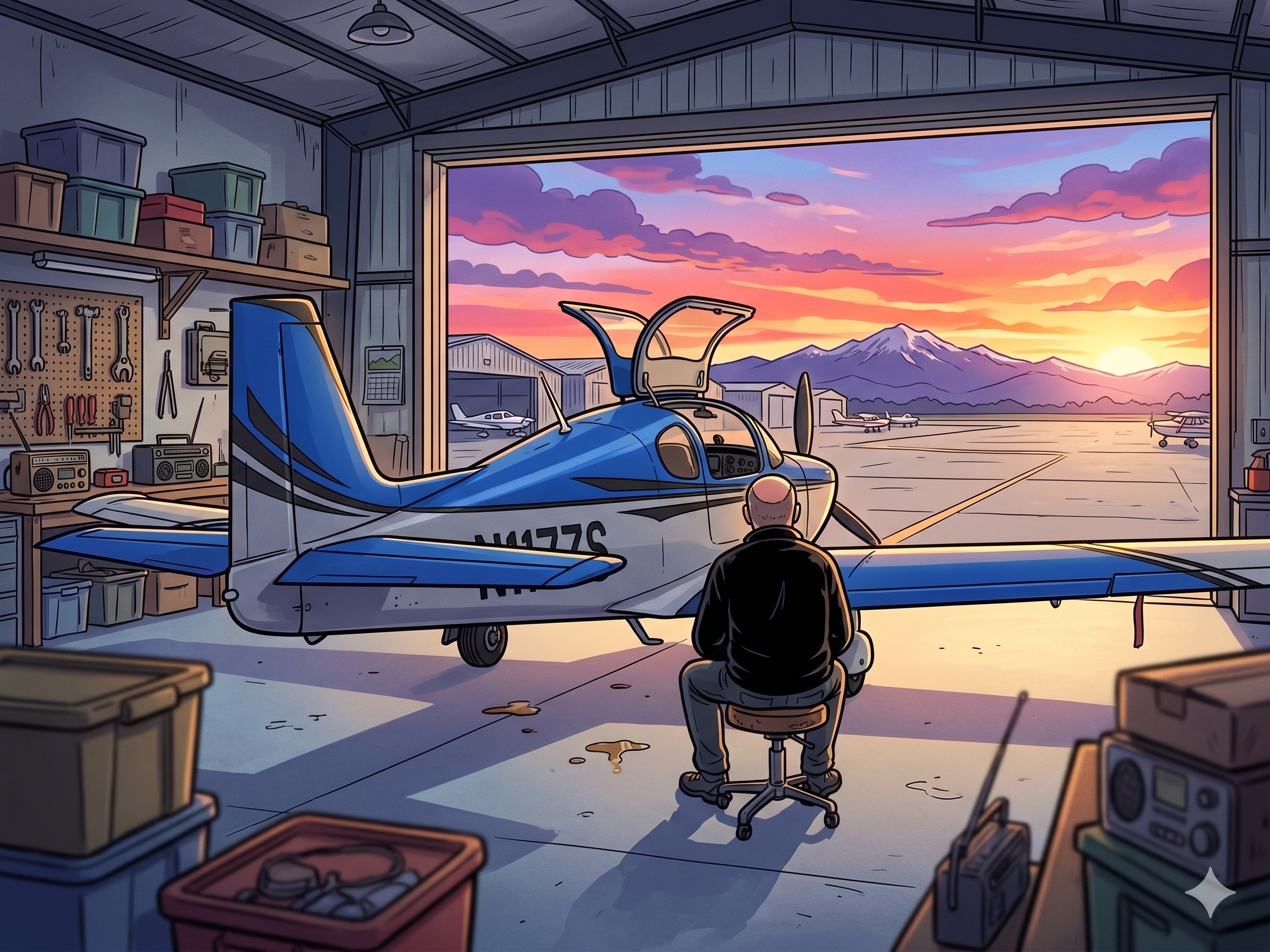
Sometime in August of 2024, I stood in a hangar in Torrance, California, looking at a pile of aluminum and wondering what I had gotten myself into. Eight months later, I was strapping into that same airplane — now fully built, tested, and signed off — for the longest flight of my life.
The ferry from KTOA to KAWO was never just a cross-country. It was the last leg of a much longer journey. Getting Roci home meant the build arc was finally closed. What comes next is just flying.

The Challenge
I had approximately four hours in the airplane when I departed KTOA. The engine had 33 hours on the tach. This was not a machine I knew well yet.
The ferry was always going to be solo — my CFII had agreed to come along as a safety pilot, but logistics fell apart at the last minute. So the variables stacked up: a brand new experimental with minimal hours, no copilot, the LA basin with LAX a few miles off my departure airport, and a route that would cover roughly the entire length of the West Coast. It was by far the longest cross-country of my flying life — I had flown cross-country trips before, but nothing close to half this distance in a single day.
Every system indication, every sound, every fuel reading carries more weight when you haven’t accumulated enough hours to know what normal looks like. I was flying and learning at the same time.
Planning the Route
The distance made at least one fuel stop non-negotiable. The question was which way to go. Two routes made sense.
The first was the inland valley route — north through the Central Valley to Chico or thereabouts, then over Shasta and up through Oregon and Washington. The advantage was staying over land the entire way with larger airports within reach if something went wrong with the airplane. The problem was Shasta. The lowest MEA on that segment sits at 10,000 feet, and without oxygen onboard and April icing conditions a real possibility at that altitude, it was a non-starter.
The second option was the coastal route — up the California coast, stop at KACV in Arcata for fuel, then continue north through Oregon and into Puget Sound. Lower MEAs, more flexibility on altitude if icing became a factor, and a more forgiving terrain profile overall. The tradeoffs were real: a few short segments over water, limited maintenance support at the en route airports, and the possibility of coastal fog at KACV. But the forecast looked good, and fog typically clears by mid-morning. I had inland alternates identified if it didn’t.


Here are some stats for the two legs:
| KTOA-KACV | KACV-KAWO | |
| Distance | 546 NM | 459 NM |
| Flight Fuel | 28 GAL | 25 GAL |
| ETE | 3+51 | 3+23 |
| En Route Altitude | 8000 FT | 9000 FT |
Coastal route it was.
Weather Planning
Weather planning for a trip of this length goes well beyond what an EFB app handles well. Garmin Pilot and its peers are excellent for preflight briefings and in-flight weather, but for multi-day route planning and pattern analysis, they fall short. The presentation is largely static imagery — surface analysis charts, prognostic charts — with limited ability to zoom into specific route segments and explore details over time.
For this trip I leaned heavily on two resources. NOAA’s Aviation Weather Center was invaluable for structured, authoritative forecast data. And Windy became my primary planning tool — it combines an impressive range of atmospheric data layers with an intuitive interface that makes it easy to visualize wind, cloud coverage, and icing conditions along a specific route over time. Critically, Windy gives you access to multiple forecast models simultaneously, which lets you cross-check predictions and get a feel for forecast confidence rather than just taking one model’s word for it. I’ll do a dedicated post on weather planning tools at some point, because the topic deserves more than a paragraph.
The window I was looking for appeared at the end of the week of April 20th, which also aligned with the completion of the remaining work at The Airplane Factory — including a fix on the co-pilot door that had opened in flight during my last training sortie and bent the gull wing hinges. Timing, for once, cooperated.

The Flight
I arrived at KTOA at 6am and had the airplane ready for a 7 o’clock departure — the time the tower opens. The preflight was thorough, the IFR flight plan was filed, and the Garmin Pilot briefing looked as expected. I was nervous. Not in a bad way, but in the way that comes with knowing the day ahead is going to demand something from you.
The first leg to KACV ran 4 hours and 15 minutes. The second, KACV to KAWO, was 3 hours and 43 minutes. Just under 8 hours of flying time, and with the fuel stop the total day stretched to around 9.
KACV is an untowered field that also handles commercial traffic. As I was sequencing for landing I heard an Airbus pilot on the radio trying to work out where exactly I was, concerned that my approach and landing might interfere with their landing. I decided the courteous move was to give them the sequence and go do a little sightseeing while they sorted themselves out. The airport was windy — mostly headwind — but the fuel stop was efficient. Refueled, got my clearance, and was back in the air in about an hour.

The airplane performed flawlessly throughout. That is worth saying plainly — no squawks, no surprises, nothing that gave me pause. What I did have was time. A lot of it. Enroute I found myself settling into the systems, cross-checking instruments, working the radios, and gradually building the mental model of how Roci flies that those first four hours hadn’t fully established.
Somewhere over northern Oregon a cloud layer appeared below my cruise altitude and stayed there. The scenic coastal route turned into a gray ceiling for the last couple of hours, which was fine — just less interesting. The Puget Sound arrival was busy, as it always is around 4pm with SEATAC commercial traffic and IFR training flights stacking up. I cancelled IFR when I got below the layer and flew the last few miles to KAWO visually.
My wife was waiting on the ramp. The airplane was home.
Lessons Learned
- Nine hours is too long to fly in a single day. I knew this going in and did it anyway. The ferry could have been split across two days with no consequence — there was no deadline, no one waiting, no reason to push it. Future long cross-countries will get more respect for what a full day in a small cockpit actually costs you. The goal is fun, and grinding through fatigue is not fun.
- Skip the double espresso before a long flight. I will leave it at that.
- Departing the LA Basin IFR was the right call. I had been anxious about navigating the airspace around LAX in an experimental I barely knew, but the instructors at the Sling Academy gave me some practical pointers and ATC handled the rest. VFR out of KTOA with LAX a few miles away would have been a different conversation entirely.
- The most useful lesson came from the fuel gauges. Early in the first leg, my right wing was showing 11 gallons when it should have been pegged at the fuel sender’s maximum of 16 — I had closer to 20 gallons aboard. I spent some time troubleshooting — even considered landing to investigate — before I noticed I was flying slightly uncoordinated. A small amount of right rudder input and the indication corrected itself immediately. The Sling wing can carry 25.5 gallons per side, but the float-type fuel sender is positioned such that it can only measure up to 16 gallons — a consequence of the wing’s tapered shape. Above that level the float is simply out of its range and the gauge reads full. But even mild uncoordinated flight is enough to shift fuel away from the float, causing a misleading low reading well below where it should be. I had known about the sender limitation, but I did not truly understand what that meant in practice until I was sitting at 8,000 feet wondering if I had a fuel problem. That is the thing about a new airplane — you can prepare thoroughly and still find yourself learning in real time. The hours in the logbook are the only thing that closes that gap.
- The iPad overheated. Multiple times. It was strapped to my leg — not mounted on the dash or stuck to a window in direct sun — and it still complained. Each time it went thermal I went back to paper and pencil for ATC instructions, the way pilots did it before glass panels existed. And honestly, I didn’t miss the EFB much. The G3X across two screens and the GTN gave me everything I needed enroute. The one place I would have preferred having it available is on an approach — Garmin Pilot’s Approach SmartCharts are genuinely useful there, and I could shoot an approach without them, but I’d rather not. For the bulk of a long cross-country the panel is more than sufficient. Worth knowing.
Home
Roci is home. She is parked in her hangar at KAWO, fuel topped off, logbook current, and ready for whatever comes next.
The build took the better part of eighteen months. Factory assist or not, it was a substantial undertaking — more demanding, more educational, and more satisfying than I expected when I signed the paperwork. The ferry closed that chapter. What opens now is the one I built her for.
There will be more posts. More flights, more systems deep-dives, more lessons learned the only way they can be — in the air. But this one felt worth marking. The airplane is home.


Leave a Reply